
We wish to pursue the truth, no matter where it leads. But to find the truth, we need imagination and skepticism, both. We will not be afraid to speculate, but we will be careful to distinguish speculation from fact. – Carl Sagan, Cosmos Introduction.
Our current goal is to spark interest in the enigmatic Mid Pleistocene Transition Impact among members of various professions. Our data is provided freely, and are open to direct collaboration, or to support your independent research.The Mid Pleistocene Impact Hypothesis is now available as two individual peer reviewed Chapters in GSA Special Papers book SPE553, In the Footsteps of Warren B. Hamilton: New Ideas in Earth Science. Chapter 23 introduces a user friendly tool kit for the evaluation of suborbital trajectories over the rotating Earth, and is available Open Access. Chapter 24 is a 30 page summary of the hypothesis and the observations and informed speculations that offer support. It has a $9.99 access fee, which goes to the GSA for their efforts. These papers are direct offshoots of our efforts at the 2019 GSA Annual Meeting in Phoenix (see next paragraph).
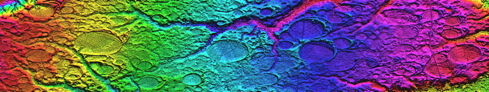
Our primary work product has been the Carolina Bay Survey, in which we have measured the size and orientation of over 50,000 landforms. Considering the evidence contained in the Survey, we maintain that interdisciplinary research into a possible cosmic origin should be encouraged. Consensus opinion does hold a cosmic impact accountable for an enigmatic Pleistocene event - the Australasian tektite strewn field - despite the failure of a 60-year search to locate the causal astrobleme. Ironically, a cosmic link to the Carolina bays is considered soundly falsified by the identical lack of a causal impact structure. Our conjecture suggests both these events are coeval with a cosmic impact into the Great Lakes area during the Mid-Pleistocene Transition, at 786 ka ± 5 k.
What is a “Carolina Bay”, and why should one care? The following quote is from the abstract of a 1998 PhD dissertation by Timothy D. Nifong:
Carolina bay depressions, once thought to number in the hundreds of thousands, are substantially rarer than previously believed. I estimate that fewer than 900 bay depressions with relatively unaltered site hydrologies remain within the study area. Those that do remain continue to disappear at an alarming rate. North and South Carolina bay depressions are important refuge for wildlife and for plant populations, including more than 65 "special status" plant species. Field observations and pertinent literature indicate that bay vegetation at relatively intact sites is highly dynamic, and that depression vegetation responds dramatically to differences in site disturbance regimes. Development of surrounding upland areas has resulted in increased isolation of Carolina bay depressions from the once pervasive role of fire as a landscape disturbance factor, and in the lowering of regional water tables. Consequently, bay vegetation has undergone an apparent "homogenization", with concomitant decreases in species richness and community diversity. If Carolina bay biodiversity is to be conserved and protected, increased and immediate attention must be given to prioritization, acquisition, and restoration of bay systems.
Gradualistic processes are considered by modern science to be responsible for the creation and evolution of the Carolina bay phenomenon. Given our LiDAR views of 50,000+ perfectly formed and aligned landforms, that approach seems silly. For a full explanation of our speculation as to the origin of the Carolina Bays, please see the Saginaw Manifold pages on Cintos.org, where we explore a cosmic impact into the Saginaw Bay area of Michigan at the time of the Mid-Pleistocene Transition, ~800,000 years ago.
A talk entitled “A Tale Of Two Craters: Coriolis-Aware Trajectory Analysis Correlates Two Pleistocene Impact Strewn Fields And Gives Michigan A Thumb” was presented at the GSA’s North-Central Section 2015 Meeting in Madison, WI. The abstract is linked above, and a PDF version of the talk is available from the GSA via the above LINK.
Pleistocene Epoch cosmic impacts have been implicated in the geomorphology of two enigmatic events. Remarkably, in both cases spirited debates remain unsettled after nearly 100 years of extensive research. Consensus opinion holds that the Australasian (AA) tektites are of terrestrial origin despite the failure to locate the putative crater, while a cosmic link to the Carolina bays is considered soundly falsified by the very same lack of a crater.
A challenging aspect of the hypothesis involves the lack of an identifiable impact structure. The conjecture suggests an extremely oblique - nearly tangential-impact, and that terrestrial material ejected from such an event would be distributed in a stylized manner. Our analysis correlates numerous proposed ejecta material emplacements - including the Carolina bays and the Goldsboro Ridge - to a cosmic impact event that struck the Laurentide ice shield at ~43°N, ~87°W. The proposed cratering impact, when combined with the scouring action of 7 full glacial ages, is seen producing the current-day Saginaw Bay Basin. We have followed the chronological constraints to a proposed date of ~787 ±5 thousand years ago.If you are a Google Earth user, you can click the GE logo here to download a starter kmz.

The survey project and all my scientific endeavors are entirely privately funded.
Cintos is the author's nom de plume. I have utilized as a handle, username and domain name for my internet presence since the 1990's.
Michael Davias
203-705-9272
Send me an email
MY ORCID ID:
 https://orcid.org/0000-0002-8960-4075
This work is licensed under a Creative Commons Attribution 4.0 International License.
Geological Research by Cintos is licensed under a Creative Commons Attribution-NonCommercial-ShareAlike 3.0 Unported License.
Based on a work at Cintos.org.
Permissions beyond the scope of this license may be available at http://cintos.org/about.html.