


Kankakee Torrent
About.com Guest Column by GeoT, January 5, 2000 http://geography.about.com/library/misc/uckankakee.htm15,500 years ago found glaciers to the north and east of the Kankakee area melting _ melting very rapidly! Lobes of ice were in areas now occupied by Lake Michigan, the State of Michigan, and eastern Indiana. Moraines to the south pooled Meltwaters, and huge lakes formed. But not for long.“The moraines were breached, and the result was among the greatest floods of the Pleistocene Epoch. This flood had impact not only in the Kankakee area, but in areas far away as well, southern Illinois in fact! The flood is known as the Kankakee Torrent. There were subsequent episodes of flooding, but none so great at this.
Massive Ponding of Water Required
When considering the excavation done by these torrents off the Saginaw lobe, it becomes obvious that the volume of water was far higher than that seen from across the moraines of the other Great Lakes during the deglaciation of the Wisconsin Ice Sheet. The common understanding is that a body of water formed against the retreating Saginaw lobe, and at some point it breached the terminal moraines entrapping it. A constraint o the volume of water ponded is the relative height of the Saginaw end moraines, as well as the fact that these moraines are at the highest elevation across the central lower Michigan peninsula understood to have hosted the Saginaw lobe.The lobe's retreat is likely to have occurred in tandem with the Huron/Erie and Michigan lobe retreats, yet those two ponds did not generate an outwash as massive as the Saginaw Torrents. That the Torrent was driven to access the Illinois River Valley by way of the Kankakee suggests that either the Michigan lobe was still in position, or the moraines dividing the two lobes were too high to be broached at that time.
The web-based presentation Of Time and the River contains a graphic which follows the early-pullback alignment ot the three lobes:

Here is a Google Earth mash up of several elements that allow us to consider an alternative to the moraine-breach concept.
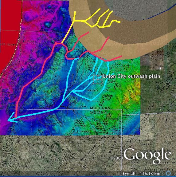
Saginaw Lobe Outwash plain and oversized valleys
We propose that a massive elliptical crater, excavated primarily from the ice sheet ~15 kya, , would have quickly become a significant lake in its own right, as it would be surrounded by ice sheet. We suggest that over a short period of time the water level would have risen enough to cause the ice sheet to hydrostatically lift from the terrain along the peripheral edges to the west and south west. Once the undermining got underway, the extensive field of tunnel channels known to exist would have been quickly created. Under our hypotesise, the "Saginaw lobe" was still present, across the Michigan-Huron-Erie interlobate area, but was disrupted by the crater pond draining event. The subsequent catastrophic outflows from the crater basin would easily create both the Kankakee Torrent as well as carving the CKRV. This process could easily have been repeated a few times over the course of the following centuries as the drained pond allowed the sheet to reattached, allowing the crater basin to re-fill again. The channels created are typically 50 meters (150 ft) deep, and often several km wide.
A corollary to the hypothesis would suggest that terrestrial ejecta lofted from the crater floor would have landed on the ice sheet across Michigan, generating vast fields of buried ice. A significant volume of research exists which has attempted to provide a reasonable solution to the extensive anomalies seen in glacial deposits and outburst flood channels in this area.
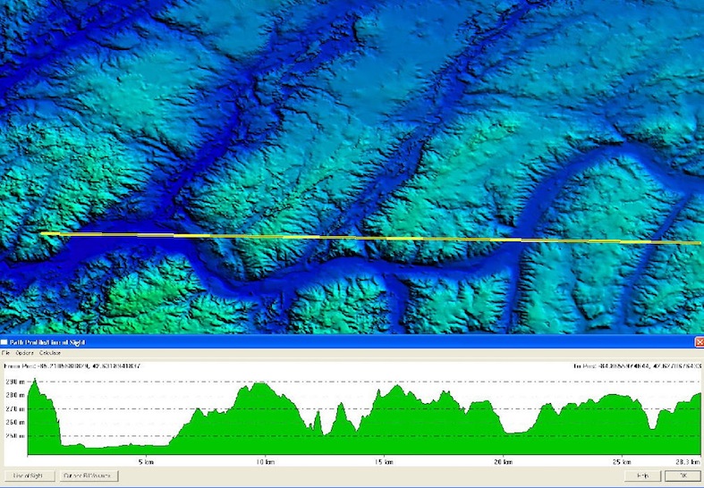
Elevation profile of Saginaw Bay outwash channles
Several sub topics in the Saginaw Bay discussion are relevant here: Unique Till, Sheetfloods, Buried Soils, Early Deglaciation and Unique Glaciation.
A set of Google Earth KML is available via this link: